
Mahmudi, Mahmudi and Subiyanto, Sawitri and Darmo Yuwono, Bambang and Prasetyo, Yudo and Sukmono, Abdi (2015) ANALISIS KETELITIAN DEM ASTER GDEM, SRTM, DAN LIDAR UNTUK IDENTIFIKASI AREA PERTANIAN TEBU BERDASARKAN PARAMETER KELERENGAN (Studi Kasus : Distrik Tubang, Kabupaten Merauke, Provinsi Papua. Undergraduate thesis, Universitas Diponegoro.
![[img]](/style/images/fileicons/application_pdf.png)
| PDF 522Kb | |
| PDF 96Kb | |
| PDF 1589Kb | |
| PDF 1597Kb | |
| PDF 1089Kb | |
| PDF 58Kb | |
| PDF 84Kb |
Abstract
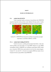
ABSTRAK Lereng merupakan permukaan bumi yang memiliki kemiringan seragam. Kelerengan merupakan perbandingan antara beda tinggi dengan jarak. Salah satu pemanfaatan informasi kelerengan yaitu dalam bidang perkebunan tebu untuk penentuan area tanam. Proses pemetaan area dengan luas ribuan hektar, tentu tidak efisien apabila menggunakan metode survey pemetaan langsung di permukaan tanah. Salah satu metode alternatif yang sering diterapkan yaitu dengan memanfaatkan elevasi dari data DEM SRTM dan ASTER yang dianggap sebagai tinggi permukaan tanah. Meski demikian, banyak literatur lain yang menjelaskan bahwa elevasi DEM (Digital Elevation Model) sebenarnya merupakan elevasi tutupan lahan di atas permukaan tanah. Dari hal itu, maka hadir metode LIDAR (Light Detection and Ranging) yang dirasa lebih baik, karena berbasis sinar laser yang dapat menjangkau informasi tinggi permukaan tanah. Penelitian ini menganalisis korelasi, dan perbedaan klasifikasi kelerengan data DEM SRTM dan ASTER terhadap klasifikasi kelerengan data LiDAR. Area yang diteliti meliputi perkebunan tebu dengan luas ±7.370 Ha di daerah Tubang, Merauke, Papua. Pembuatan peta kelerengan mengikuti SOP (Standard Operating Procedures) yang dikeluarkan oleh BIG (Badan Informasi Geospasial) pada tahun 2012, tentang pengolahan data untuk pemetaan kemiringan lereng nomor 03.01.11.02. Dimana garis besar tahap pengolahannya meliputi gridding, definisi sistem proyeksi, klasifikasi kelerengan, klustering, penghalusan, dan generalisasi. Sedangkan pembagian jenis klasifikasi kelerengan mengikuti aturan yang dibuat oleh Puslittanak (Pusat Penelitian Tanah dan Agroklimat), hal tersebut mengingat penelitian ini berkaitan dengan kondisi tanah pertanian. Hasil dari penelitian ini berupa tiga buah peta kelerengan, dan tiga buah peta kesesuaian lahan pertanian tebu berdasarkan parameter kelerengan skala 1:30,000 dari data LIDAR, SRTM, dan ASTER. Hasil proses interpolasi grid menunjukkan bahwa data yang paling akurat yaitu LiDAR dengan nilai standar deviasi ±0,3674013m; selanjutnya SRTM sebesar ±8,0916394m; dan terakhir ASTER sebesar ±9,8854329m. Setelah dilakukan uji ketinggian data terhadap titik kontrol BM dan peta RBI, diketahui bahwa data LiDAR memiliki selisih paling baik dengan standar deviasi ±0,078m dan ±1,387m; kemudian SRTM ±0,422m dan ±4,339m; ASTER ±0,297m dan ±7,979m. Meski demikian, dalam perhitungan manual ditunjukkan bahwa ketiga data menghasilkan analisis kemiringan lereng yang sama dengan RBI, selisih dan standar deviasi ketiganya kurang dari ±0,4%. Kemudian hasil uji korelasi dan signifikansi luas hasil klasifikasi kelerengan LiDAR menunjukkan bahwa hubungan terhadap SRTM searah sebesar 49,6% (Cukup), sedangkan terhadap ASTER tidak searah sebesar 57,8% (Kuat). Nilai selisih luas rata-rata antara LiDAR dengan SRTM sebesar 3.382.840 m², sedangkan dengan ASTER sebesar 5.547.200 m². Selisih luas area sesuai tanam tebu SRTM terhadap LiDAR yaitu 4.702.697,081m², sedangkan ASTER terhadap LiDAR yaitu 12.733.548,477m². Persamaan jenis klasifikasi area sesuai tanam ASTER terhadap LiDAR yaitu 34,82%; sedangkan SRTM terhadap LiDAR 29,80%. Kata Kunci : ASTER, Lereng, LiDAR, SRTM , Tebu ABSTRACT Slopes are the earth's surface that have a sloping uniform. Slope is the value of the height difference and distance ratio. One of information usages of slope are in the field of sugarcane plantations especially for the determination of the planting area. The mapping process of thousands acres of area is certainly not efficient when using directly mapping survey method. One of alternative methods that usually applied is by using the elevation data of DEM SRTM and ASTER which considered as a high ground area. However, many other literatures explain that the elevation of DEM (Digital Elevation Model) is actually a level of land cover elevation above ground. This condition triggers the present method of LIDAR (Light Detection and Ranging) that is considered better than the previous methods, due to the laser beam based which possibly measures the height of terrain. This study analyze the relationship and classification differences of slope DEM SRTM and ASTER data with the classification slope LiDAR data. Area examined in this research is the sugarcane plantations area with the vast of ± 7,370 hectares in Tubang, Merauke, Papua. Map making slope is cited from SOP (Standard Operating Procedures) issued by BIG (Badan Informasi Geospasial) in 2012 related to the data processing for mapping slope number 03.01.11.02. Whereas, the outline of the data processing stages are including gridding, definition of projection system, slope classification, clustering, smoothing, and generalization. This study relates to the condition of agricultural land, so the distribution of slope classification types following the rules made by Puslittanak (Pusat Penelitian Tanah dan Agroklimat). The results of this study are three slope maps and three sugarcane plantation area maps based on slope parameter with a scale of 1:30,000 of LiDAR, SRTM and ASTER data. The result of grid interpolation revealed that the best accurate is LiDAR with a standard deviation of ±0.3674013m, then SRTM ±8.0916394m, and the last is ASTER ±9.8854329m. The testing of height data toward the BM control point and RBI maps showed that LiDAR data has the best difference with a standard deviation of ± 1.387 m, then SRTM ± 4.339 m, and ASTER ± 7.979 m. However, the manual calculations indicated that the three data produced the same slope analysis with the RBI, differentiation and standard deviations are less than ± 0.4 m. Then the results of correlation and significance of the slope broad classification showed a 49.6% direct relationship between SRTM and LIDAR (considered to be enough), whereas a 57.8% indirect relationship between LIDAR and ASTER (considered to be strong). The area difference between LiDAR and SRTM is 3,382,840 m², whereas between LiDAR and ASTER is 5,547,200 m². The difference of sugarcane plantation area between SRTM and LiDAR is 4,702,697.081 m², and between ASTER and LiDAR is 12,733,548.477 m². The similarity of classification sugarcane plantation area ASTER and LiDAR a 34.82%, whereas SRTM and LiDAR a 29.80%. Keywords : ASTER, LiDAR, Slope, SRTM, Sugarcane
| Item Type: | Thesis (Undergraduate) |
|---|---|
| Subjects: | G Geography. Anthropology. Recreation > G Geography (General) |
| Divisions: | Faculty of Engineering > Department of Geodesic Engineering Faculty of Engineering > Department of Geodesic Engineering |
| ID Code: | 45502 |
| Deposited By: | INVALID USER |
| Deposited On: | 14 Mar 2016 20:44 |
| Last Modified: | 14 Mar 2016 20:44 |
Repository Staff Only: item control page
