
VARA DIBA KUSUMO, AGATHA DIMITRI and Kahar, Sutomo and Subiyanto, Sawitri and Awaluddin, Moehammad (2015) ANALISIS PERUBAHAN ZONA NILAI TANAH AKIBAT PERUBAHAN PENGGUNAAN LAHAN DI KECAMATAN TEMBALANG KOTA SEMARANG. Undergraduate thesis, Universitas Diponegoro.
![[img]](/style/images/fileicons/application_pdf.png)
| PDF 869Kb | |
| PDF 108Kb | |
| PDF 612Kb | |
| PDF 2194Kb | |
| PDF 863Kb | |
| PDF 87Kb | |
| PDF 86Kb |
Abstract
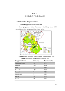
ABSTRAK Kota Semarang adalah ibukota Provinsi Jawa Tengah, Indonesia yang terletak di 6°58 ′0 ″ LU 110°25 ′0 ″BT. Semarang terdiri dari 16 kecamatan, salah satunya adalah Kecamatan Tembalang dengan jumlah kelurahan 12. Semakin bertambahnya tahun, Tembalang menjadi salah satu kecamatan yang cukup padat. Banyaknya penduduk dan aktifitas yang terjadi menyebabkan perubahan lahan di Tembalang. Sehingga berpengaruh pada perubahan nilai/harga tanah di wilayah tersebut. Penelitian ini awalnya dilakukan pembuatan peta zona nilai tanah Kecamatan Tembalang menggunakan software microsoft excel dan software pengolahan SIG. Kemudian untuk pembuatan peta perubahan penggunaan lahan juga menggunakan software pengolahan SIG. Hasil Penelitian menunjukkan dalam rentang waktu tahun 2010 sampai 2013 perubahan nilai tanah akibat perubahan penggunaan lahan terjadi di 19 titik dengan empat tipe perubahan yaitu tegalan menjadi perumahan, tegalan menjadi tanah kosong, sawah menjadi perumahan, tanah kosong menjadi perumahan Kata Kunci : Perubahan lahan, nilai tanah ABSTRACT Semarang is the capital city of East Java, Indonesia, which is located in 6o58 ‘0 “ N 110o25 ‘0 “E. Semarang consist of 16 sub-district, one of them is Tembalang sub-district with 12 village. With years to come, Tembalang is becoming one of the most populous sub-districts. With the increasing amount of inhabitant and activity, it leads to land alteration in Tembalang. So it reacts in the changes of value/cost of land in that area. This study was originally conducted a zone map making of Tembalang sub-district using Microsoft Excel software and SIG processing. Later on, to make map of land use alteration, it is also use SIG processing software. The result show that in 2010 until 2013 time span, the land value alteration because of land use alteration that happened in 19 point with the changing type that is moor changing into housing, moor changing into wasteland, field changing into housing, wasteland changing into housing. Keywords : Land alteration, soil’s value
| Item Type: | Thesis (Undergraduate) |
|---|---|
| Subjects: | G Geography. Anthropology. Recreation > GB Physical geography |
| Divisions: | Faculty of Engineering > Department of Geodesic Engineering Faculty of Engineering > Department of Geodesic Engineering |
| ID Code: | 45125 |
| Deposited By: | INVALID USER |
| Deposited On: | 14 Mar 2016 20:46 |
| Last Modified: | 14 Mar 2016 20:46 |
Repository Staff Only: item control page
