
Niam, Aufan and Suprayogi, Andri and Awaluddin, Moehammad and Putra Wijaya, Arwan (2014) APLIKASI OPENSTREETMAP UNTUK SISTEM INFORMASI GEOGRAFIS KANTOR PELAYANAN UMUM ( STUDI KASUS : KOTA SALATIGA ). Undergraduate thesis, Universitas Diponegoro.
![[img]](/style/images/fileicons/application_pdf.png)
| PDF - Published Version 400Kb | |
| PDF 207Kb | |
| PDF 1250Kb | |
| PDF 2297Kb | |
![[img]](/style/images/fileicons/text_html.png)
| HTML 2939Kb | |
| PDF 2939Kb | |
| PDF 86Kb | |
| PDF 89Kb |

Abstract
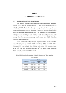
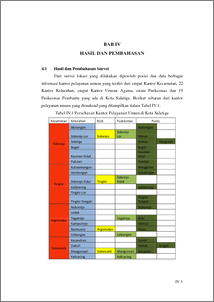
ABSTRAK Kota Salatiga merupakan kota dengan wilayah yang padat dan perkembangan yang pesat baik dari segi ekonomi, sosial, industri maupun budaya. Secara administratif Kota Salatiga terbagi menjadi empat kecamatan dan 22 kelurahan dengan jumlah penduduk pada tahun 2012 sebanyak 186.087 jiwa. Kantor pelayanan umum mempunyai tugas untuk melaksanakan pelayanan sesuai tugasnya kepada masyarakat di Kota Salatiga. Guna menunjang dan mendukung pelayanan secara maksimal perlu adanya suatu aplikasi dari sistem informasi geografis yang menampilkan lokasi persebaran dan informasi terkait dari kantor pelayanan umum tersebut.Salah satu media penyampaian informasi yang lengkap dan dapat diakses dimana saja dengan cepat adalah dengan menggunakan website. Dalam penelitian ini menggunakan data spasial koordinat posisi hasi survei dengan GPS Handheld dan data atribut yang berupa informasi yang didapat dari kantor terkait. Untuk merancang dan membangun sebuah informasi geografis kantor pelayanan umum di wilayah Kota Salatiga yaitu dengan memanfaatkan fasilitasOpenStreetMap (OSM) yang kemudian dikembangkan menggunakan kerangka website HTML, MySQL dengan fitur phpMyadmin yang digunakan sebagai basis data dan OpenStreetMap API. Hasil akhir penelitian ini berupa aplikasi SIG untuk kantor pelayanan umum di Kota Salatiga yang menyajikan informasi dari masing-masing kantor kelurahan, kecamatan, KUA dan Puskesmas menggunakan fitur-fitur dan peta dari fasilitas OpenStreetMap. Kata Kunci: Kota Salatiga, Kantor Pelayanan Umum, SIG, OpenStreetMap ABSTRACT Salatiga is a city with populous region and growths rapidly in every aspects such economy, social, indusry and culture. Salatiga Municipality was administratively divided into four districts and 22 villages, with the total population in 2012 were 186.087 persons. Public office is responsible to provide services according their responsibility to public in Salatiga Municipality. To support and facilitate how to provide services effectively, there is a way to use an application based Geographic Information System (GIS) to display the distributed location and related information from each public offices. One of media to share the information completely and easily access anywhere is by using website. This research using spatial data coordinates of the position from collected coordinate points using GPS Handheld and atributtes data are the information from related offices. To stake and build a geographic information to public office in Salatiga Manicipality is using facilities of OpenstreetMap then developed using HTML website framework, MySQL with phpMyAdmin features used as database and OpenStreetMap API. The final result of this research is the application of GIS public service offices in Salatiga Municipality equipped with information of each village offices, district offices, religious offices, and public health service offices. The application used features and fasilities from OpenStreetMap. Keywords : Salatiga Municipality, public service offices, GIS, OpenStreetMap
| Item Type: | Thesis (Undergraduate) |
|---|---|
| Subjects: | G Geography. Anthropology. Recreation > GA Mathematical geography. Cartography |
| Divisions: | Faculty of Engineering > Department of Geodesic Engineering Faculty of Engineering > Department of Geodesic Engineering |
| ID Code: | 45090 |
| Deposited By: | INVALID USER |
| Deposited On: | 14 Mar 2016 20:50 |
| Last Modified: | 14 Mar 2016 20:50 |
Repository Staff Only: item control page
