
Niyartama , Thaqibul Fikri (2001) Pendugaan penyebaran Kerakal dengan konfigurasi Schlumberger "Studi kasus desa Banjarejo Kec. Boja". Undergraduate thesis, FMIPA UNDIP.
![[img]](/style/images/fileicons/application_pdf.png) | PDF Restricted to Repository staff only 4047Kb | |
| PDF 21Kb | |
| PDF 379Kb | |
| PDF 636Kb | |
| PDF 487Kb | |
| PDF 636Kb | |
| PDF 721Kb | |
| PDF Restricted to Repository staff only 1555Kb | |
| PDF 344Kb | |
| PDF 354Kb | |
| PDF 1284Kb |

Abstract
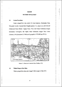
Penyelidikan geofisika telah dilakukan di Desa Banjarejo.1Inetode yang digunakan adalah Geolistrik tahanan jenis berkonfigurasi elektroda Schlumberger sedemikian hingga diperoleh data Vertical Electrical Sounding (VES). Penyelidikan tersebut bertujuan untuk mendapatkan pola penyebaran dan volum estimasi kerakal di lokasi penelitian yang berdekatan dengan endapan teras sungai. Data lapangan yang diperoleh berupa 22 data VES, iselanjutnya diinterpretasi dengan menggunakan program Shift Depth Shift Resistivity (SDSR) serta metode matching curve (penyamaan lengkung) sebagai interpretasi pendukung untuk memperkuat hasil interpretasi SDSR. Volume kerakal kemudian dihitung berdasarkan volume kontur tiap penyebaran lateral terhadap beberapa variasi kedalaman. Berdasarkan penampang tahanan jenis hasil interpretasi program SDSR ditemukan bahwa rata-rata terdapat tip hingga empat lapisan geollogi di area penelitian. Nilai tahanan jenis untuk lapisan yang diduga mengandung kerakal berkisar antara 29,7 S2m sampai 450 fltn, dengan ketebalan berkisar antara 0,72 meter sampai dengan 6 meter pada kedalaman 0,83 meter sampai 6,911, meter dad permukaan tanah. Penyebaran kerakal yang signifikan adalah di sepanjang endapan teras yang terbentuk di sisi kanan dan kid sungai dengan lebar berkisar antara 30 sampai dengan 80 meter dengan kcenderungan merata pada kedalaman berkisar 2' meter dad permukaan tanah. Volume total kerakal hasil estimasi pada daerah penelitian adalah 144.775 in3. A geophysical investigation has been conducted into Banjarejo village. The applied geophysical method was Geoelectrical Resistivity of Schlumberger electrode configuration with the result that Vertical Electrical Sounding data (VES). The investigation had the purpose to gain the distribution pattern and estimation volume of gravel at the nearby of river terrace sediment. The obtained field data that 22 VES data was then interpreted by means of Shift Depth Shift Resistivity (SDSR) program and was supported by matching curve method in order to convince the interpretation result. The grayel volume was therefore estimated based on contour volume of each lateral distribution versus some depth variation. Based on the resistivity section that resulted by SDSR interpretation program, three to four geology layers were found, on an average at the research area. The resistivity value of the predicted gravel-bearing layer is varying at 29, 7 to 450 an, with the thick is varying at 0,72 to 6 In in the depth of 0,83 to 6,91 In from the land surface. The significance gravel distribution is found on all along of the terrace sediment that was formed on the right and left side of river with the width varying from 30 to 80 in and it's even distribution trend are fOund in the depth of 2 m from the land surface. The estimated total volume of gravel at the research area is 144.775 rn3.
| Item Type: | Thesis (Undergraduate) |
|---|---|
| Subjects: | Q Science > QC Physics |
| Divisions: | Faculty of Science and Mathematics > Department of Physics |
| ID Code: | 30548 |
| Deposited By: | Mr UPT Perpus 1 |
| Deposited On: | 02 Nov 2011 12:11 |
| Last Modified: | 02 Nov 2011 14:31 |
Repository Staff Only: item control page
